by Bill Leutz
–In this article, I have chosen to use the name “Clark’s” Lake because that was how the lake was named in all pertinent documents during the period under investigation, as well as being the name I knew it by in the late 1940’s.
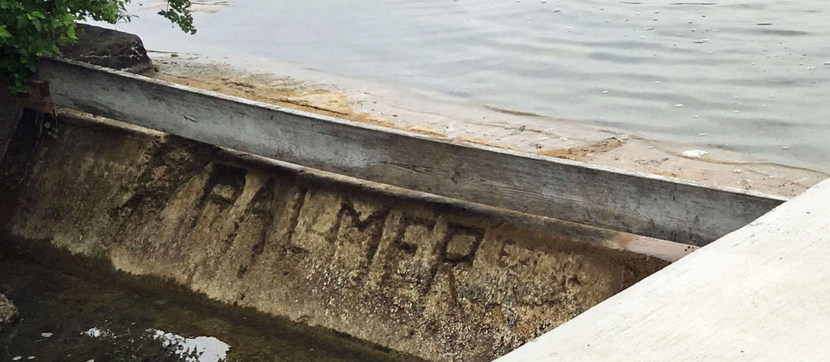
The origin of the original dam at the east end of Clark’s Lake, where the lake empties into the small tributary of Goose Creek on its way to the Raisin River and Lake Erie, has recently become a matter of some debate. At the date of this writing, no definitive date of construction of the dam has been discovered. I attempted to find the date last summer, but a search of records at the Jackson Public Library, and a request for data from the Jackson County Drain Commissioner came up empty. The recent initiation of the Dam Strong Project has renewed interest in this subject. There have been a number of earlier articles this year, speculating on its history. At least four known repairs to the dam have occurred – in 1934, 1954, 2012, and 2017. Any visitor to the dam will also notice the name “Palmer” etched in the concrete in large letters. What this signifies is still uncertain, but it presumably commemorates someone involved in the dam’s construction.
Ted Ligibel’s book indicates the dam was in existence when Leo Steinem built the nearby Ocean Beach Pier in 1928. The Steinem’s also owned the dam. In an article on this website, Gloria Steinem is quoted, “I have memories of playing on that dam as a child…our family was also responsible for its repair as well as for dredging the creek on the other side of Ocean Beach Road.” She also recalls being told that it was the only dam in Michigan on private property.
In a previous article, Dr. Phil Riley, whose family came to Clark Lake in 1937, recalls learning about the dam from his father. Philip Riley Sr. once told Phil Jr. the current (or predecessor to current) dam was built in about 1934 by a man named Morehouse…”. Since we know the dam was there when the Steinem family owned the property in 1928, the Morehouse story suggest a 1934 repair, during the Steinem ownership. Another major repair of the dam occurred in 1954, also reported in an article on this website.
A consideration of old maps may hold some additional clues as to its initial construction. However, it should first be mentioned that drawing conclusions from old plat maps has at least one drawback. Generally, the lakefront lot descriptions were measured “to the shore of the lake,” with no further description of where that shoreline lay. This implies that the exact lakeshore configuration was changeable and therefore of less importance than were its other dimensions. Thus, a conclusion based solely upon the lakeshore configuration might not be as accurate as hoped.
Acknowledging this fact, I still feel some information can be gleaned. I have located maps showing the general position and shape of Clark’s Lake dating from 1839, 1844, 1873, 1874, and 1911. Of these, the two best are the Plat Maps of 1874 and 1911. Recognizing that the construction of the 2-3 foot tall dam would have raised water levels around the lake by at least that amount, one might assume that the shoreline on these maps might give a clue. Comparing the 1874 and 1911 maps suggests a considerable change in the shore line of 1) the west side of Eagle Point, 2) North Bay, on the NW side of the lake and 3) a few other places where shallow water still extends from the shoreline today. The total surface area of the lake also appears noticeably greater in the 1911 map. From this, a conclusion could be drawn that the dam first appeared sometime between 1874 and 1911.
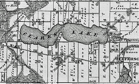
1874 Plat Map
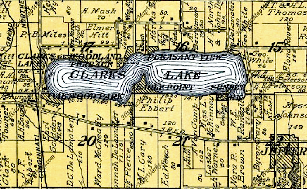
1911 Plat Map
I recently saw another plat map that was not dated. However, further research confirmed that it was from an 1894 plat map of Columbia Township. Although more recent, this map appears very similar to the 1874 map. Key indicators that have changed between 1874 and this more recent map (and that can be dated), are:
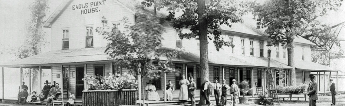
1) The existence of the Eagle Point House.
2) The ownership of the Hardy Farm property which now belongs to my sister Ann Swain.
3) The ownership of the property containing the dam.
We know that the tavern that became Eagle Point House was constructed in 1878 and that William Hardy bought his farm in 1888. In addition, this map indicates the landowner of the dam property in 1894 was O. B. Palmer.
Oscar Benjamin Palmer was the son of Jonathon Randall Palmer, an early Columbia Township settler from New York. Jonathon came to Clark’s Lake in 1835, but soon thereafter established a farm in Section 34. This farm would have included most of the southeast shore of present day Lake Columbia. The name Oscar B. Palmer, can be found in association with other properties in the area, indicating that he may have speculated on land at various times in his life. The Palmer name appears to tie to the name etched in the concrete of the dam in 1934. Land records show that Oscar B. Palmer owned that property from 1889 until 1896.
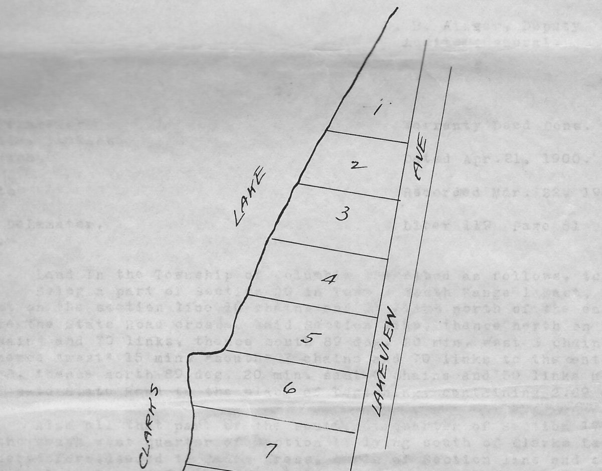
1893 Plat of west side of Eagle Point
My own property plat, dating from the incorporation of the Eagle Point subdivision in 1893, shows a significant variation in the smoothness of the shoreline of the lake between lots 5 and 6. Although small by overall lake standards, this small point of land creates a corresponding ebayment extending about 20 feet to the east. It does not appear on pre-1894 maps but does on the 1911 and later maps. It is clearly visible today, but does not appear to extend to the lake bottom directly offshore. This implies a lower water depth would not show this feature as part of the lakeshore, and would lead one to conclude that the water had already risen by 1893. Since it would have taken at least a winter for the water to rise those additional 2-3 feet, one could consider that the dam was probably in place by the fall of 1892.”
I also have copies of a small collection of old photographs that are in the possession of cousin Sue Shawaker Moesser’s family. They show our combined families’ visits to the lake prior to their purchase of the property at 1090 Eagle Point Drive in 1921. Two of these collections show family activities at rental properties on the west shore of the Eagle Point in 1914 and on the east shore in 1917. All of these pictures provide supporting evidence that the current shoreline was in existence by at least 1914, as indicated on the 1911 map.

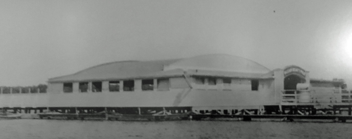
The Eagle Point House was in operation since the early 1880’s and, with the opening of the Pleasant View Hotel in 1891, interest in developing the lake would have rapidly grown. The erection of a private dam to stabilize water levels would have been a natural conclusion at this time. Unfortunately, since it appears to have been a private project, possibly with the financial support of a few large landowners interested in the development of the lake as a tourist destination, there do not appear to be records of the construction. At the proposed time of construction, Property owners were nearly all farmers, living on the surrounding roads with their property backing up to the lake. There were essentially no lakefront dwellings, and therefore no property owners who would have been damaged by rising lake levels, thus no County or Township hearing may have been required.
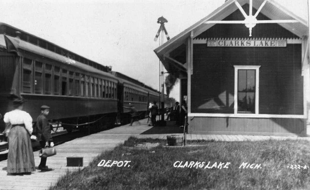
It is interesting to note that all of the early property subdivisions took place after 1892. The earliest, at Eagle Point in June 1893, was apparently too recent to be noted on the 1894 plat map. Eagle Point was followed by Pleasant View in 1894, and Oakwood Park and Woodland Terrace by 1896. The completion of the Cincinnati, Jackson, and Mackinaw Railroad in 1896, with its depot on Vining Street, would have provided the final phase in this early development.
All of this, speculative as some of it is, leads to a strong indication for a range of the dates of construction of the original Clark’s Lake dam between 1889 and 1892. A renewed survey of local newspapers and/or Township records during these years may eventually yield information of the original dam construction that could further narrow this time range.